Dec 16, 2020
A New Satellite Can Peer Inside Buildings, Day or Night
Posted by Quinn Sena in category: satellites
Cloud cover, and even in some cases walls, can’t block this ultra-precise satellite’s view.
Cloud cover, and even in some cases walls, can’t block this ultra-precise satellite’s view.
The satellites Blue Canyon developed for DARPA’s Blackjack program — based on the company’s commercial X-SAT bus — passed a critical design review.
WASHINGTON — Small satellite manufacturer Blue Canyon Technologies has been cleared to produce its first two satellites for the Defense Advanced Research Projects Agency’s Blackjack program, the company announced Dec. 14.
DARPA plans to deploy up to 20 spacecraft in low-Earth orbit that will be connected by optical inter-satellite links and provide communications, missile tracking and navigation services.
Continue reading “DARPA okays Blue Canyon’s satellites for Blackjack program” »
😃 So the old ways still work!
A startup called SpinLaunch wants to do away with costly launch rockets. Let’s look at the physics.
National Geographic magazines and Indiana Jones movies might have you picturing archaeologists excavating near Egyptian pyramids, Stonehenge, and Machu Picchu. And some of us do work at these famous places.
But archaeologists like us want to learn about how people from the past lived all over the planet.
We rely on left-behind artifacts to help fill out that picture. We need to excavate in places where there’s evidence of human activity – those clues from the past aren’t always as obvious as a giant pyramid, though.
More reliable measurements would help operators decide when to safely retire aging craft.
When a spacecraft launches, it uses roughly 75–90% of its propellant getting into orbit. The remaini.

We all have images in our mind of rocket launches from Cape Canaveral Air Force Station hurtling astronauts into space and satellites into orbit.
But those launches may be a thing of the past as a new generation of drones that can do the same job cheaper, safer and better steps into play.
Continue reading “Huge drone set to launch satellites in mid-air” »

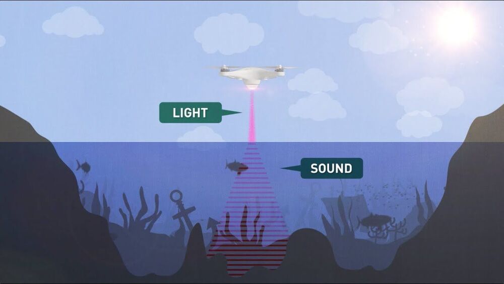
Radar and LiDAR have been incredibly quick and effective tools for mapping and surveying the Earth’s surface from aircraft and satellites, but while they can deliver accurate readings through cloud and even forest canopy cover, they can’t tell you what’s below the surface of the sea. Seawater absorbs far too much of the signal.
Sonar remains the most effective way to map out the sea floor – but the vast majority of the oceans that form 70 percent of the Earth’s surface remain unmapped, because sonic waves have hitherto only been able to be sent out from underwater. Sound waves sent from air into water lose more than 99.9 percent of their energy in the translation; it’s why the outside world goes so wonderfully silent when you dive down to the bottom of the pool. The meagre remaining 0.1 percent of the energy does create a sonar signal, but that loses a further 99.9 percent of its energy upon coming back up from the water into the air.
Continue reading “Stanford engineers invent a sonar device that works outside the water” »
Global #connectivity lets for #digitalidentity for billions of people worldwide, giving them access to #telehealth, #education, #careers, #entertainment and #finance services, as well as raising #cybersecurity and #dataprivacy concernsRe-sharing. Starlink can help telemedicine become more reliable and available to people in need. Especially those in rurual or far flung locations.
Video Source/Credit: SpaceX Youtube Channel
Continue reading “Elon Musk’s Starlink May Potentially Revolutionize Healthcare” »
SpaceX’s satellite internet broadband service is expanding by leaps and bounds — and leaping across borders.
