Archive for the ‘satellites’ category: Page 148
May 16, 2019
SpaceX will send 60 satellites to orbit tonight in the first of a dozen launches to set up Starlink
Posted by Carse Peel in categories: internet, satellites
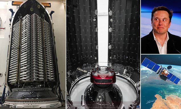
In the first of a dozen launches to set up its Starlink network that could provide high-speed internet all around the world…
SpaceX is now eyeing tonight for the lift-off of a Falcon 9 rocket towing the first of 60 Starlink satellites after postponing its planned Wednesday launch due to high winds.
May 11, 2019
SpaceX CEO Elon Musk reveals radical Starlink redesign for 60-satellite launch
Posted by Klaus Baldauf in categories: Elon Musk, satellites
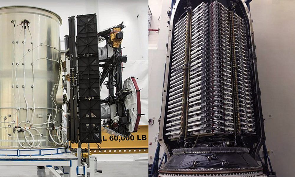
SpaceX CEO Elon Musk has published the first official photo of the company’s near-final Starlink design and confirmed that Falcon 9 will launch a staggering 60 satellites on May 15th.
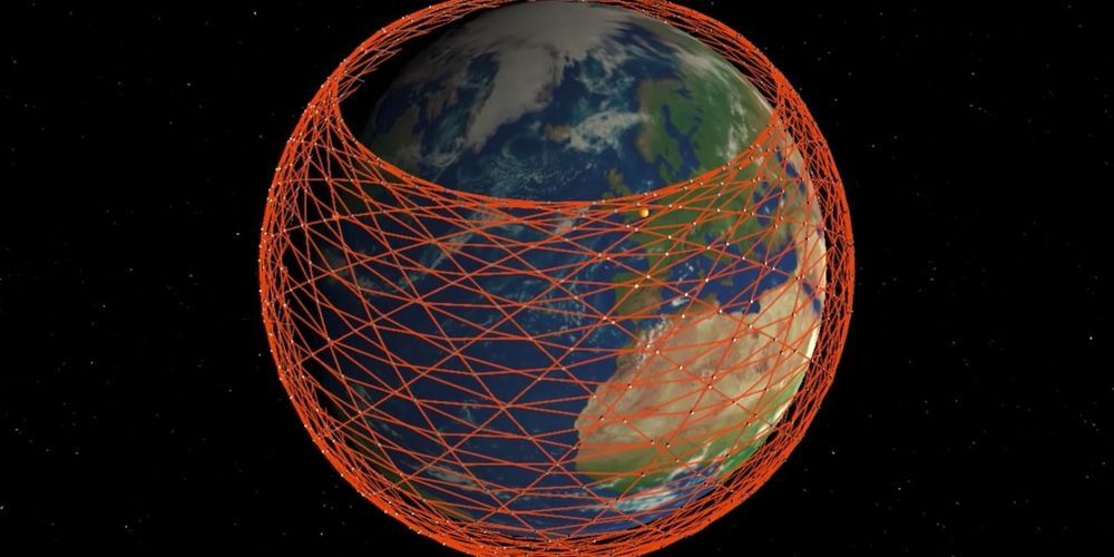
Known internally as Starlink v0.9, this mission will not be the first launch of operational satellites, but it will be the first internal SpaceX mission with a dedicated Falcon 9 launch. Additionally, the payload will be the heaviest yet launched by SpaceX, signifying an extraordinarily ambitious first step towards realizing the company’s ~12,000-satellite Starlink megaconstellation.
May 10, 2019
SpaceX to launch dozens of ‘test satellites’ for its Starlink program
Posted by Carse Peel in categories: internet, satellites

SpaceX will launch dozens of ‘test satellites’ for its Starlink program next week as it ramps up efforts to create high speed global internet…
According to Gwynne Shotwell, SpaceX’s president and CEO, the company will launch dozens of satellites next week as a demonstration for project Starlink.
Continue reading “SpaceX to launch dozens of ‘test satellites’ for its Starlink program” »
May 9, 2019
Elon Musk & Jeff Bezos Can Save American Households $30+ Billion with LEO Satellites
Posted by Tracy R. Atkins in categories: Elon Musk, internet, satellites
Low Earth Orbit (LEO) satellites are still in their nascency, but analysis of BroadbandNow US market pricing data suggests that the technology could save American households more than $30 billion per year by intensifying broadband competition.
LEO satellites, such as the constellations planned by Elon Musk’s SpaceX Starlink project and Jeff Bezos’ Project Kuiper, promise to bring low-latency broadband internet to millions of Americans. LEO satellite orbit extremely close to earth, between 99 to 1200 miles versus 22,000 miles of traditional GEO satellites, which means less time to transfer information (lower latency) and a quality of service comparable to wired broadband cable and fiber providers. The arrays will be precisely mapped into massive constellations to maximize coverage.
LEO technology will offer robust internet access to underserved and rural communities lacking wired, low-latency broadband options. The arrival of this emergent technology is likely to drive down monthly internet prices for hundreds of millions of Americans.
May 9, 2019
NRL tests sensor on-orbit the ISS to protect space-based assets
Posted by Quinn Sena in categories: particle physics, satellites
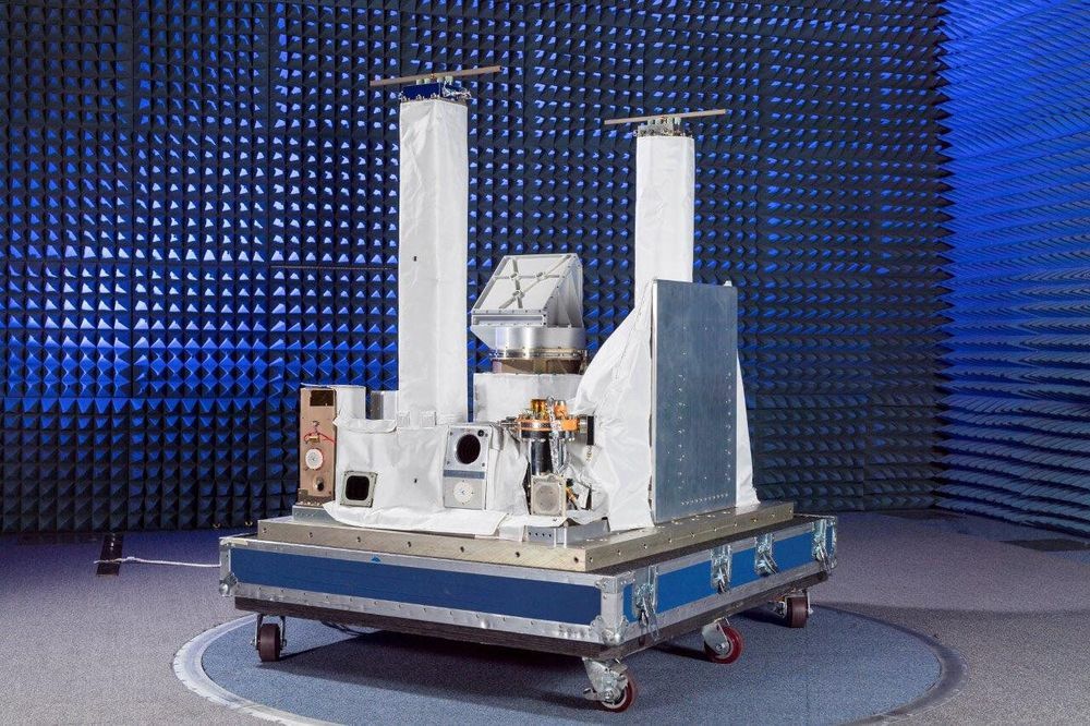
Developed by the U.S. Naval Research Laboratory Plasma Physics Division, in conjunction with the Spacecraft Engineering Department, the Space PlasmA Diagnostic suitE (SPADE) experiment launched from Kennedy Space Center in Florida to the International Space Station onboard the SpaceX Dragon resupply mission (CRS-17), May 4.
Integrated onto the Space Test Program-Houston 6 (STP-H6) pallet, SPADE is designed to monitor background space plasma conditions on-orbit the International Space Station and provide early warning of the onset of hazardous levels of spacecraft charging.
The space environment is filled with a collection of electrically charged particles, plasma, and properties that depend on variable solar conditions. Satellite operations in space require continuous monitored plasma conditions and the results it has on spacecraft.
Continue reading “NRL tests sensor on-orbit the ISS to protect space-based assets” »
May 6, 2019
Telescopes in space for even sharper images of black holes
Posted by Genevieve Klien in categories: cosmology, satellites
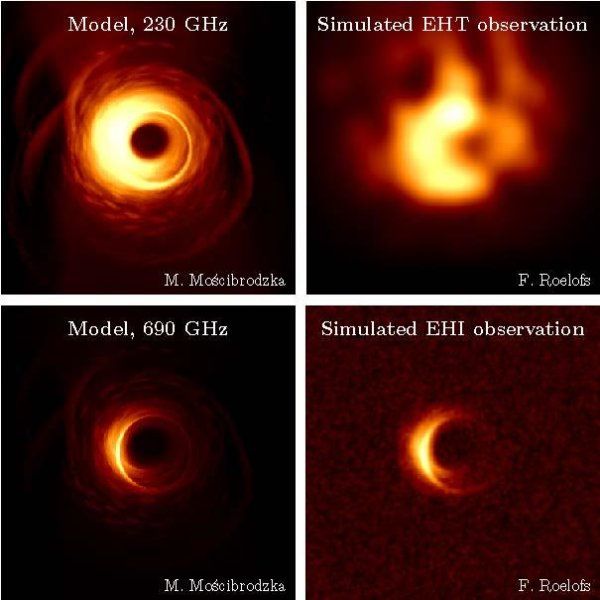
The idea is to place two or three satellites in circular orbit around the Earth to observe black holes. The concept goes by the name Event Horizon Imager (EHI). In their new study, the scientists present simulations of what images of the black hole Sagittarius A would look if they were taken by satellites like these.
More than five times as sharp
“There are lots of advantages to using satellites instead of permanent radio telescopes on Earth, as with the Event Horizon Telescope (EHT),” says Freek Roelofs, a PhD candidate at Radboud University and the lead author of the article. “In space, you can make observations at higher radio frequencies, because the frequencies from Earth are filtered out by the atmosphere. The distances between the telescopes in space are also larger. This allows us to take a big step forward. We would be able to take images with a resolution more than five times what is possible with the EHT.”
Continue reading “Telescopes in space for even sharper images of black holes” »
May 4, 2019
How Isro satellites tracked Fani, saved many lives
Posted by Saúl Morales Rodriguéz in category: satellites
CHENNAI: As meteorologists observed a trough of low in the southern http://timesofindia.indiatimes.com/topic/Indian-Ocean”>Indian Ocean more than a week ago, five Indian satellites kept a constant eye on the system as it brewed into cyclone Fani.
As it developed into an “extremely severe cyclone”, the satellites launched by Isro sent data every 15 minutes to the ground station, helping track and forecast its movement and save hundreds of lives.
According to IMD, data from satellites Insat-3D, Insat-3DR, Scatsat-1, Oceansat-2 and Megha Tropiques was used to study the intensity, location and cloud cover around Fani. There was a cloud cover around the eye of the storm up to 1000km radius, though the rain clouds were only up to a radius of 100 to 200km. The rest were at a height of around 10,000feet.
Continue reading “How Isro satellites tracked Fani, saved many lives” »
May 1, 2019
NASA: Manufacturer’s Lies Caused Two Satellite Launches to Fail
Posted by Michael Lance in categories: government, satellites
The lies cost NASA more than $700 million and years of scientific work.
On Tuesday, NASA revealed that aluminum manufacturer Sapa Profiles, Inc. (SPI) “altered test results and provided false certifications” for materials used in the rockets, causing their fairings not to separate as designed.
“For nearly 20 years, Sapa Profiles and Sapa Extrusions [SPI’s corporate parent] falsified critical tests on the aluminum they sold — tests that their customers, including the U.S. government, depended on to ensure the reliability of the aluminum they purchased,” Assistant Attorney General Brian A. Benczkowski said in an April 23 statement.
Continue reading “NASA: Manufacturer’s Lies Caused Two Satellite Launches to Fail” »
May 1, 2019
Team develops system to legally test GPS spoofing vulnerabilities in automated vehicles
Posted by Quinn Sena in categories: cybercrime/malcode, law, mobile phones, robotics/AI, satellites
Southwest Research Institute has developed a cyber security system to test for vulnerabilities in automated vehicles and other technologies that use GPS receivers for positioning, navigation and timing.
“This is a legal way for us to improve the cyber resilience of autonomous vehicles by demonstrating a transmission of spoofed or manipulated GPS signals to allow for analysis of system responses,” said Victor Murray, head of SwRI’s Cyber Physical Systems Group in the Intelligent Systems Division.
GPS spoofing is a malicious attack that broadcasts incorrect signals to deceive GPS receivers, while GPS manipulation modifies a real GPS signal. GPS satellites orbiting the Earth pinpoint physical locations of GPS receivers embedded in everything from smartphones to ground vehicles and aircraft. SwRI designed the new tool to meet United States federal regulations. Testing for GPS vulnerabilities in a mobile environment had previously been difficult because federal law prohibits over-the-air re-transmission of GPS signals without prior authorization.
